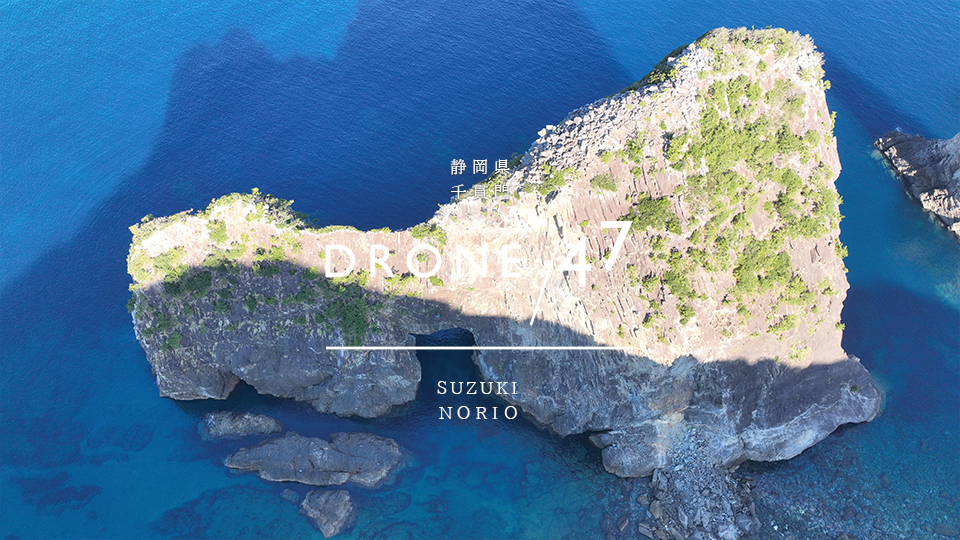
Shizuoka Prefecture Matsuzaki Town "Senkanmon" 2023 Summer Drone Aerial Photography

Worth seeing - worth a thousand kanmon (1,000 kanmon) The wide area of the southern Izu Peninsula, including Nishiizu and Minamiizu, was created by undersea volcanoes and volcanic islands that erupted before Izu collided with Honshu. Senganmon, located at the end of the promenade, and Eboshiyama, visible to the right of Senganmon, are the remains of a "magma passage" that was once underground in an undersea volcano...

Drone aerial photography of "Mikomoto Island" in Shimoda City, Shizuoka Prefecture

An island where you can see hammerhead sharks! We have obtained all necessary permission to take photos. *As the currents are strong in this area, it is necessary to consult with an expert. Japan's oldest Western-style stone lighthouse Mikomotojima is a small uninhabited island with only a lighthouse, located about 8km offshore from Yumigahama Beach on the Izu Peninsula. There are many reefs around the island, making it difficult to navigate by sea.

Drone aerial photography of Hirakubo Beach, Ishigaki Island, Okinawa Prefecture

砂浜がキレイで砂質もサラサラ!透明度の高い海 全ての許可を取り撮影を行なっております。 石垣島の北部・平久保にある極上のビーチそれが!平久保ビーチになります。 1:白い砂浜と透明度高いエメラルドグリーンの海 2:緑のトンネルを抜けると石垣島ブルーの世界 3:遠浅で穏やかな海。青の世界に包まれ…

Okinawa Prefecture Yonaguni Island "Sona area giant coral reef" drone aerial photography

沖縄・与那国島に手つかずの巨大サンゴ礁 全長4キロ 洞窟のような地形も... 沖縄県 与那国島「祖納地域 巨大サンゴ礁」ドローン空撮 全ての許可を取り撮影を行なっております。 祖納地域巨大サンゴ礁になります。 ここ最近発見された祖納地域 巨大サンゴ礁はテレビでも特集され注目のスポットになりま…

Drone aerial photography of Akashi Beach, Ishigaki Island, Okinawa Prefecture

コの字に描くように延びゆく南国のロングビーチ 石垣島北東部に位置する絶景が望める平久保半島の先にある天然ビーチが明石海岸(明石ビーチ)!!コの字に描くように延びゆく南国のロングビーチは設備が何もない自然の状態で残っています。 明石海岸は石垣島の平久保半島の明石集落にある広々とした人気のない穴…

Okinawa Prefecture Ishigaki Island "Kabira Bay" drone aerial photography 

ミシュラン・グリーンガイド・ジャポン3つ星獲得! 全ての許可を取り撮影を行なっております。石垣島NO.1絶景スポット川平湾(かびらわん)は、沖縄県に数ある離島の中でも、とても大きな石垣島の北西部にある名勝地で、日本百景にも選ばれている、石垣島に旅行に行くなら絶対に見逃してはいけない絶景スポッ…

Yonaguni Town, Okinawa Prefecture: Undersea Topography Photographed by Drone 

与那国ブルー 全ての許可を取り撮影を行なっております。★一般社団法人 与那国町観光協会完全バックアップ 沖縄本島から南西へ約509km、石垣島から約127km、東京から約1,900km。周囲27.49km、面積28.96k㎡の日本最西端の地、与那国島。隣接する台湾とは、約111kmの距離にあ…

Drone aerial photography of Tsurugisaki Lighthouse in Miura City, Kanagawa Prefecture

Designated as one of Kanagawa's 50 most scenic spots. All permission was obtained for photography. Tsurugizaki is a cape located at the southeastern tip of the Miura Peninsula, in Matsuwa, Minamishimoura-cho, Miura City, Kanagawa Prefecture. It is written as "Tsurugizaki" on maps by the Geospatial Information Authority of Japan, and as "Tsurugisaki" on nautical charts by the Japan Coast Guard. There are also multiple other names for this place name. At the tip is Tsurugisaki Lighthouse...

Tokyo, Ogasawara Islands, Hahajima "Shin-Yuhigaoka" drone aerial photography

The Earth is round! We obtained all the necessary permission to take the photos. We would like to introduce one of the best sunset spots on Hahajima. This spot offers a panoramic view of Mukojima, Tairajima, Anejima, and other islands. During humpback whale season, whale watching is also available. Many tourists gather at Shin-Yuhigaoka to be amazed by the setting sun. The Earth is "round"...