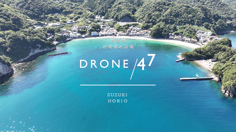
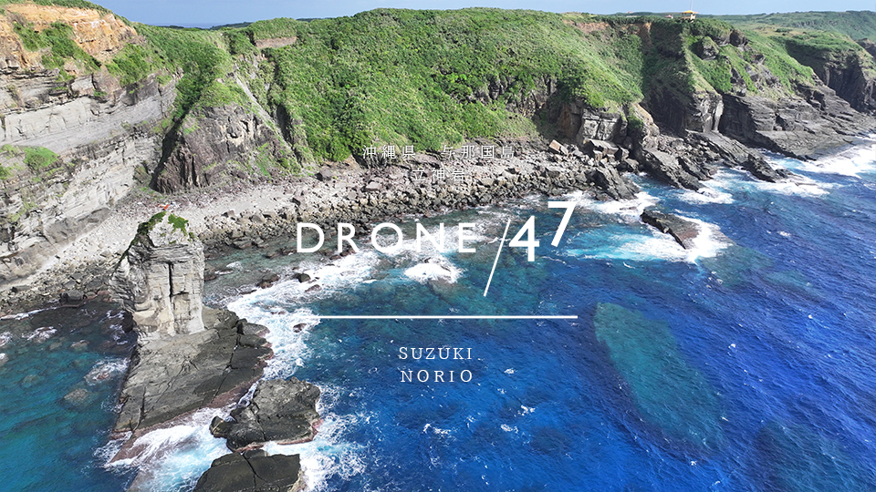
Yonaguni Island, Okinawa Prefecture "Tategami Rock" drone aerial photography

The symbol of Yonaguni Island! We obtain all the necessary permission to film. ★Fully backed by the Yonaguni Town Tourism Association General Incorporated Association★DRONE/47 owns the largest number of drone aerial footage of Yonaguni Island in Japan. Tachigamiiwa Rock, which stands on the southeastern coast of the island, is the symbol of Yonaguni Island. Long ago, people climbed this rock to collect seabird eggs…

Yonaguni Island, Okinawa Prefecture "Dr. Koto Clinic Location" Drone Aerial Photography

The most famous spot on Yonaguni Island! We have obtained all the necessary permits to film here. ★Fully backed by the Yonaguni Town Tourism Association General Incorporated Association★DRONE/47 owns the largest number of drone aerial footage of Yonaguni Island in Japan. It is a must-see for tourists on Yonaguni Island, as seen in the movie "Dr. Koto's Clinic." They have also created a map of the filming locations on Yonaguni Island. [Distribution...

Yonaguni Island, Okinawa Prefecture "Umabanazaki North Ranch" drone aerial photography

This is the place where Dr. Koto used to sit and look out at the sea. We obtained all the necessary permission to take the photos. ★Fully backed by the Yonaguni Town Tourism Association★DRONE/47 is the No.1 company in Japan for drone aerial footage of Yonaguni Island. Umahanazaki...A cape in the North Ranch, northwest of Yonaguni Airport. There is a sign for "Umahanazaki" on the main road, so the entrance is...

Drone aerial photography of "Minami Ranch" on Yonaguni Island, Okinawa Prefecture

Horses come first! We obtain all necessary permission to film. ★Fully backed by the Yonaguni Town Tourism Association★DRONE/47 is the No.1 company in Japan for drone footage of Yonaguni Island. Located in the southern part of Yonaguni Island, this ranch became famous for the TV drama "Dr. Koto's Clinic." The fences were installed to keep the horses from going outside the ranch...

Yonaguni Island, Okinawa Prefecture "Rokujo Beach" drone aerial photography

We obtained all the necessary permission to film the "Secret Place" in the TV drama "Dr. Koto Clinic." ★Fully backed by the Yonaguni Town Tourism Association General Incorporated Association★DRONE/47 owns the largest number of drone aerial footage of Yonaguni Island in Japan. This small beach in the northern part of Yonaguni Island is also known as the most scenic beach on Yonaguni Island...

Drone aerial photography of Nishizaki, "the westernmost point of Japan," Yonaguni Island, Okinawa Prefecture

24 degrees 27 minutes north, 122 degrees 56 minutes east We have obtained all necessary permission to film. ★Fully backed by the Yonaguni Town Tourism Association General Incorporated Association★DRONE/47 owns the largest number of drone aerial footage of Yonaguni Island in Japan What is the westernmost point of Japan? ? "Yonaguni Island" in Okinawa Prefecture The westernmost point of Japan is Yonaguni Island in the Yaeyama Islands of Okinawa Prefecture. …

Shizuoka Prefecture Matsuzakicho Iwaji "Kumomi Sengen Shrine" 2023 Summer Drone Aerial Photography

A shrine located on Mt. Eboshi at an altitude of 162m. All permission has been obtained for filming. Kumomi Sengen Shrine is a shrine located on Mt. Eboshi at an altitude of 162m, in Kumomi, Matsuzaki-cho, Kamo-gun, Shizuoka Prefecture, in the southwest of the Izu Peninsula. It is also called Kumomi Shrine and Ontake Sengen-gu. It is a rare shrine among the approximately 2,000 Sengen Shrines in Japan, dedicated to Iwanagahime-no-Mikoto…

Tokyo, Ogasawara Islands, Chichijima "Sakaiura Beach" drone aerial photography

Sakaiura Beach is a beach snorkeling spot where you can explore sunken ships. All permits have been obtained for filming. Sakaiura Beach is a major snorkeling spot on Chichijima Island. It is also famous as a tourist spot where you can see World War II relics and the sunken ship of a military supply ship up close. The Hamae Maru (1911-1915), which is stranded a few dozen meters from the shoreline, is located on the shoreline.

Shizuoka Prefecture Matsuzaki Town Kumomi "Ushikuiwa" 2023 Summer Drone Aerial Photography

The big rock is called "Oushitsuki" and the small rock is called "Koushitsuki". Ushitsukiiwa Two islands, one big and one small, can be seen offshore. Long ago, a storm caused a great flood in the Kumomi area, and houses and livestock were swept out to sea, but the next morning, cows were found safely ashore on a rock in front of the port. Since then, the residents of Kumomi have called this island Ushitsukiiwa. Now...